


Description
Unparalleled coastal chart coverage
- Provides industry-leading coverage, clarity and detail with updated coastal charts that feature integrated Garmin and Navionics® data
- Auto Guidance1 technology calculates a route using your desired depth and overhead clearance and provides a suggested path to follow
- Includes Depth Range Shading for up to 10 depth ranges, enabling you to view your target depth at a glance
- Up to 1-foot contours provide a more accurate depiction of the bottom structure for improved fishing charts and navigation in swamps, canals and marinas
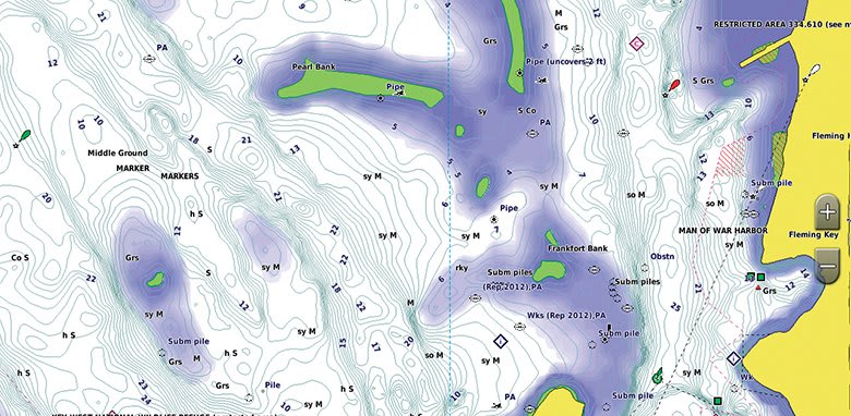
BlueChart g3 coastal charts provide industry-leading coverage, clarity and detail with integrated Garmin and Navionics data. Also included is Auto Guidance1 technology, which uses your desired depth and overhead clearance to calculate routes and provide a suggested path to follow — overlaid onto your chart. NOAA raster cartography is also available as a free downloadable feature via the ActiveCaptain app. It gives your chartplotter paper chartlike views of NOAA-surveyed areas in which individual points of interest are labelled with corresponding longitude and latitude information. Worldwide coverage is available by regions as accessory cards or via download; each region is sold separately.
Auto Guidance technology
The Auto Guidance feature1 calculates a suggested route using your desired depth and overhead clearance.
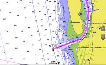
Depth Range Shading
This feature displays high-resolution Depth Range Shading for up to 10 depth ranges, so you can view your designated target depth.
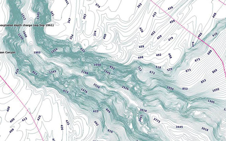
Detailed Contours
BlueChart g3 charts feature 1-foot contours that provide a more accurate depiction of bottom structure for improved fishing charts and enhanced detail in swamps, canals and port plans.
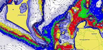
Shallow Water Shading
To aid in navigation, Shallow Water Shading allows map shading at a user-defined depth to give a clear picture of shallow waters to avoid.
Compatibility
Featuring integrated coastal and inland content, the newest generation of Garmin Navionics+™ and premium Navionics Vision+™ cartography offers superior coverage, clarity and detail on your compatible Garmin chartplotter. If your current chartplotter or marine handheld is not compatible with the Garmin Navionics+ format, you can still enjoy Garmin's previous generation of BlueChart® g3 coastal charts and LakeVü™ g3 inland maps — until you’re ready for a chartplotter upgrade. If you own another brand of chartplotter, you can purchase Navionics charts.
| ECHOMAP™ CHARTPLOTTERS | BlueChart g3/BlueChart® g3 Vision and LakeVü g3/LakeVü™ g3 Ultra Compatible1 | Garmin Navionics+/Garmin Navionics Vision+ Compatible |
|---|---|---|
| ECHOMAP ULTRA 2 (10/12) | ✓ | ✓ |
| ECHOMAP UHD2 (6/7/9) | ✓ | ✓ |
| ECHOMAP UHD2 (5/7) | ✓ | ✓ |
| ECHOMAP ULTRA (10/12) | ✓ | ✓ |
| ECHOMAP UHD (7/9) | ✓ | ✓ |
| ECHOMAP UHD (6) | ✓ | |
| ECHOMAP PLUS (4/6/7/9) | ✓ | |
| ECHOMAP CHIRP (4/5/7/9) | ✓ | |
| ECHOMAP (NON CHIRP) | ✓ |
| GPSMAP® CHARTPLOTTERS | BlueChart g3/BlueChart g3 Vision and LakeVü g3/LakeVü g3 Ultra Compatible1 | Garmin Navionics+/Garmin Navionics Vision+ Compatible |
|---|---|---|
| GPSMAP 9500 BB | ✓ | ✓ |
| GPSMAP 9000 | ✓ | ✓ |
| GPSMAP 8400/8600 | ✓ | ✓ |
| GPSMAP 8700 BB | ✓ | ✓ |
| GPSMAP 7x3/9x3/12x3/16x3 | ✓ | ✓ |
| GPSMAP 10x2/12x2 | ✓ | ✓ |
| GPSMAP 8500 BB | ✓ | |
| GPSMAP 8000 | ✓ | |
| GPSMAP 7400/7600 | ✓ | |
| GPSMAP 7x2/9x2 | ✓ | |
| GPSMAP 12x2 TOUCH | ✓ | ✓ |
| GPSMAP 7x2/9x2/12x2 PLUS | ✓ | ✓ |
| GPSMAP 4000/5000/6000/7000 | ✓ | |
| GPSMAP 7x1/5x7 | ✓ | |
| GPSMAP 8x0/10x0 | ✓ | |
| GPSMAP A12 | ✓ | ✓ |
| GPSMAP A7 | ✓ | ✓ |
| OEM | BlueChart g3/BlueChart g3 Vision and LakeVü g3/LakeVü g3 Ultra Compatible1 | Garmin Navionics+/Garmin Navionics Vision+ Compatible |
|---|---|---|
| GPSMAP 8400/8600 - VOLVO | ✓ | ✓ |
| GPSMAP 8000 - VOLVO | ✓ | |
| GPSMAP 7400/7600 - VOLVO | ✓ | |
| GPSMAP 7x3/9x3/12x3 - VOLVO | ✓ | ✓ |
| GPSMAP A12 - VOLVO | ✓ | ✓ |
| YAMAHA® CL7 | ✓ |
| HANDHELDS AND WEARABLES | BlueChart g3/BlueChart g3 Vision and LakeVü g3/LakeVü g3 Ultra Compatible1 | Garmin Navionics+/Garmin Navionics Vision+ Compatible |
|---|---|---|
| QUATIX® 7 | ✓ | |
| QUATIX 6 | ✓ | |
| GPSMAP 86x/86sc/86i | ✓ | |
| GPSMAP 78/78s/78sc | ✓ | |
| GPSMAP 79 | ✓ | |
| GPSMAP 276 | ✓ |
| CARD READERS | BlueChart g3/BlueChart g3 Vision and LakeVü g3/LakeVü g3 Ultra Compatible1 | Garmin Navionics+/Garmin Navionics Vision+ Compatible |
|---|---|---|
| GARMIN CARD READER | ✓ | |
| USB CARD READER | ✓ | ✓ |
*BlueChart and LakeVü charts will not work on ECHOMAP and GPSMAP chartplotters that have Garmin Navionics+ charts built in or are networked to a device that has Garmin Navionics+ charts built in.
Related Products
Related Products

Garmin BlueChart G3 - Ireland West Coast
Garmin

Garmin BlueChart G3 - Europe Atlantic Coast - VEU722L
Garmin

Garmin Navionics+ Chart - Irish Sea NSEU004R
Garmin


Garmin Navionics Vision+ Chart - Irish Sea
Navionics

Imray Irish Sea Pilot
Imray


